
Aboriginal stone-walled intertidal fishtrap morphology, function and chronology investigated with high-resolution close-range Unmanned Aerial Vehicle photogrammetry
Kreij, Anna, Scriffignano, Jason, Rosendahl, Daniel, Nagel, Texas, and Ulm, Sean (2018) Aboriginal stone-walled intertidal fishtrap morphology, function and chronology investigated with high-resolution close-range Unmanned Aerial Vehicle photogrammetry. Journal of Archaeological Science, 96. pp. 148-161.
Graphical Abstract
|
PDF (Published Version)
- Published Version
Available under License Creative Commons Attribution. Download (4MB) | Preview |
|
|
Image (PNG) (Graphical Abstract)
- Supplemental Material
Available under License Creative Commons Attribution. Download (218kB) | Preview |

Abstract
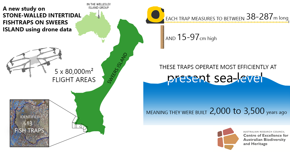
Stone-walled intertidal fishtraps surround the Australian coastline and are among the largest structures built by Indigenous Australians. Globally, fishtraps are considered important elements in food production, domestication, territoriality and ceremonial landscapes, yet the level of detail in documentation is highly varied and scholarly fishtrap knowledge sparse. Comparative analysis is currently restricted by a lack of detail and reproducibility in recording, hindering analysis of morphology, function and chronology. In this study we employ high-resolution close-range Unmanned Aerial Vehicle (UAV) photogrammetry and a suite of spatial information analytical techniques to investigate the Kaiadilt Aboriginal stone-walled intertidal fishtraps of Sweers Island, southern Gulf of Carpentaria, Australia. Tidal inundation modelling is undertaken to assess (1) fishtrap working range, (2) individual and simultaneous trap function, (3) seasonal functionality and (4) chronology based on function relative to sea-level history. Thirteen fishtraps were identified in the study area, ranging from 38m to 287m in length. Flow accumulation indicates that shape and placement of fishtraps reflects underlying topography. Inundation modelling shows that all fishtraps operate most efficiently at present mean-sea level (PMSL), indicating construction in the last 3500 years. Quantitative recording techniques, analytical procedures and terminology developed in this study provide an opportunity to improve approaches to recording large-scale stone features and standardise documentation of stone-walled intertidal fishtrap sites.
| Item ID: | 54492 |
|---|---|
| Item Type: | Article (Research - C1) |
| ISSN: | 1095-9238 |
| Keywords: | fishtraps; high-resolution photogrammetry; UAV; GIS; standardised recording; quantitative analysis; sea-level modelling; aquaculture |
| Related URLs: | |
| Additional Information: | © 2018 The Authors. Published by Elsevier Ltd. This is an open access article under the CC BY license (http://creativecommons.org/licenses/by/4.0/). |
| Funders: | Australian Research Council (ARC) |
| Projects and Grants: | Australian Research Council Centre of Excellence for Australian Biodiversity and Heritage (CE170100015), Australian Research Council Discovery Project (DP120103179), Australian Research Council Future Fellowship (FT120100656) |
| Date Deposited: | 06 Jul 2018 02:00 |
| FoR Codes: | 45 INDIGENOUS STUDIES > 4501 Aboriginal and Torres Strait Islander culture, language and history > 450101 Aboriginal and Torres Strait Islander archaeology @ 50% 43 HISTORY, HERITAGE AND ARCHAEOLOGY > 4301 Archaeology > 430101 Archaeological science @ 50% |
| SEO Codes: | 95 CULTURAL UNDERSTANDING > 9505 Understanding Past Societies > 950503 Understanding Australias Past @ 50% 95 CULTURAL UNDERSTANDING > 9503 Heritage > 950302 Conserving Aboriginal and Torres Strait Islander Heritage @ 50% |
| Downloads: |
Total: 2362 Last 12 Months: 29 |
| More Statistics |
Actions (Repository Staff Only)
 |
Item Control Page |